


Hygge by Scandinavia
Svecia, Dania, Et Norvegia | Antique Scandinavia Map Print (1665)
Svecia, Dania, Et Norvegia | Antique Scandinavia Map Print (1665)
Couldn't load pickup availability
Joan Blaeu (1596–1673)
Read more
Read more
Joan Blaeu (1596–1673)
A grand 17th-century map of Scandinavia with historical depth, decorative detail, and timeless Nordic character.
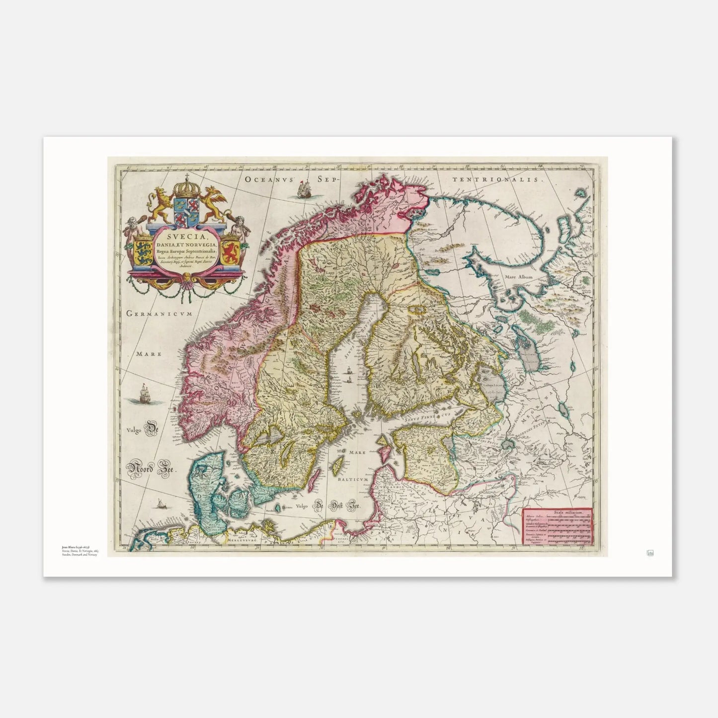
Svecia, Dania, Et Norvegia by Joan Blaeu, dated 1665, is an antique atlas map of Sweden, Denmark, Norway, and parts of Finland. It measures 54 x 43 cm, has a scale of 1:4,500,000, and was published in Amsterdam as part of Blaeu’s famous Atlas Maior.
This is the kind of map print that works beautifully in a home office, hallway, living room, or gallery wall. It has the balance many people want from antique map decor: enough detail to keep drawing the eye, but calm enough to sit naturally in a Scandinavian interior.
The map is especially strong visually because it combines geography with classic Dutch Golden Age cartography. The uploaded material describes intricate topographical detail, labeled seas, sailing ships, and an elaborate cartouche with coats of arms. It also notes that the map was hand-colored and created with the high level of craftsmanship that made Blaeu’s work so admired.
Historically, this poster carries real weight. Blaeu’s Atlas Maior is described in the uploaded source as being “considered by many to be the greatest atlas ever published,” praised for its comprehensiveness, engraving, color, and overall production. That gives this Scandinavian map print both decorative appeal and genuine cartographic significance.
For customers who love Scandinavian design, Nordic history, vintage maps, and wall art with story and structure, this print offers all of that in one piece. It is not just a map of place, but a map of how 17th-century Europe imagined and presented the North.
“Considered by many to be the greatest atlas ever published.”
Source Blaeu’s Atlas Maior
Why this map print stands out
- A classic antique Scandinavia map by Joan Blaeu, one of the great names in historical cartography
- Shows Sweden, Denmark, Norway, and parts of Finland in a richly detailed 17th-century composition
- Features decorative ships, an elaborate cartouche, labeled seas, and hand-colored regional detail
- Part of the celebrated Atlas Maior, issued in multiple languages and admired for exceptional production quality
- Ideal for Scandinavian wall art, Nordic interiors, studies, offices, and heritage-inspired gallery walls
Product details
| Detail | Information |
|---|---|
| Title | Svecia, Dania, Et Norvegia |
| Cartographer | Joan Blaeu |
| Date | 1665 |
| Publisher | Joan Blaeu |
| Publisher location | Amsterdam |
| Type | Atlas map |
| Region shown | Scandinavia |
| Countries included | Sweden, Norway, Denmark, Finland |
| Scale | 1:4,500,000 |
| Original size | 54 x 43 cm |
| Publication | Atlas Maior Sive Cosmographia Blaviana |


Created on request - near you.
- We only print when you order, using FSC-certified or equivalent matte paper (200 gsm, 0.26 mm) for a refined, non-reflective finish.
- Local production across the USA, Europe, Australia, New Zealand, and Brazil helps reduce shipping distance and emissions.

Compare size
How is your poster going to look on your wall?
- Choosing a selection results in a full page refresh.
- Opens in a new window.