


Buy more and get free shipping
Stavanger 1940 | Historic Norwegian Map Print
Stavanger 1940 | Historic Norwegian Map Print
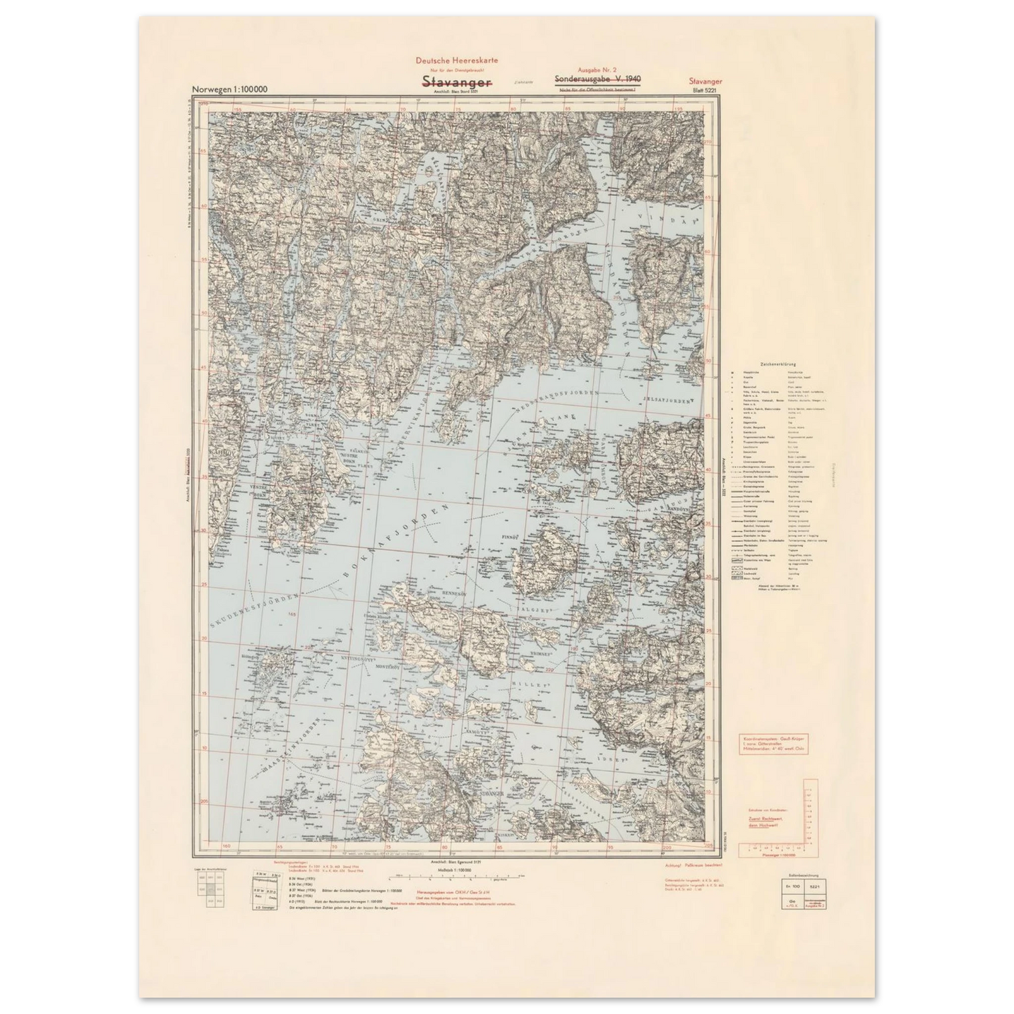
This Stavanger map poster brings historic Norwegian cartography, coastal geography and Scandinavian heritage into the home. Based on a 1940 German military topographic map of the Stavanger region, this historic Norway map printshows fjords, islands, coastal routes, terrain, settlements and place names around one of Norway’s most important harbour cities.
Couldn't load pickup availability
Secure and trusted checkout
Your payment information is processed securely. We do not store payment details nor have access to your payment information.
- Locally produced
- Easy Returns
- Quality Guarantee
Details
Details
This Stavanger map poster brings historic Norwegian cartography, coastal geography and Scandinavian heritage into the home. Based on a 1940 German military topographic map of the Stavanger region, this historic Norway map printshows fjords, islands, coastal routes, terrain, settlements and place names around one of Norway’s most important harbour cities.
It is ideal for Norwegian heritage homes, studies, offices, libraries, hallways and gallery walls where wall art should feel historic, detailed and deeply connected to place.
Quick Highlights
- Historic map print of Stavanger, Norway
- Based on a Deutsche Heereskarte map from 1940
- Scale shown on the map: Norwegen 1:100000
- Covers Stavanger, fjords, islands and the surrounding coastal landscape
- Strong choice for Norwegian and Scandinavian heritage homes
- Premium matte paper with a smooth, non-reflective finish
- Made when you order, close to the customer where possible
- Available in 8 sizes
About This Stavanger Map Poster
This Stavanger poster is based on a historic topographic map titled Stavanger, issued as part of the German Deutsche Heereskarte map series during World War II. The map itself is marked Norwegen 1:100000, Sonderausgabe V 1940 and Ausgabe Nr. 2.
As a map print, it shows much more than the city alone. The surrounding fjords, islands, coastline and terrain are central to the composition, making it a detailed portrait of the Stavanger region as a coastal landscape.
Stavanger’s history is closely tied to its harbour, medieval roots and western Norwegian coastal geography. Store norske leksikon notes that the city’s history is traditionally connected with the building of Stavanger Cathedral around 1125, while its later development was shaped by trade, shipping, herring fisheries and industry.
This makes the poster especially meaningful for people with roots in Stavanger, Rogaland or western Norway — and for anyone who loves old Norwegian maps, maritime history and Scandinavian place-based wall art.
Why It Works in a Scandinavian Home
| Room | Why it works |
|---|---|
| Home office | Adds geographic detail, history and structure |
| Study or library | Pairs naturally with books, wood and classic interiors |
| Hallway | Gives the home a strong Norwegian heritage first impression |
| Living room | Works as a calm but detailed conversation piece |
| Gallery wall | Combines well with Norwegian art, old maps and Nordic nature prints |
Size Guide
| Size in cm | Approx. size in inches | Best for |
|---|---|---|
| 13 × 18 cm | 5 × 7 in | Small frames, shelves and desk styling |
| 27 × 35 cm | 11 × 14 in | Compact gallery walls and smaller rooms |
| 30 × 40 cm | 12 × 16 in | Hallways, shelves and smaller wall displays |
| 40 × 50 cm | 16 × 20 in | Offices, bedrooms and balanced gallery walls |
| 50 × 70 cm | 20 × 28 in | Living rooms, studies and statement map displays |
| 60 × 80 cm | 24 × 32 in | Larger rooms and heritage walls |
| 70 × 100 cm | 28 × 40 in | Spacious interiors and large Scandinavian gallery walls |
| 75 × 100 cm | 30 × 40 in | Large wall spaces and strong map statement styling |
Product Information
| Feature | Details |
|---|---|
| Product type | Historic map print poster |
| Map title | Stavanger |
| Map series | Deutsche Heereskarte |
| Region | Stavanger and surrounding coastal region |
| Country | Norway |
| Year shown | 1940 |
| Scale shown | 1:100,000 |
| Edition shown | Sonderausgabe V 1940 / Ausgabe Nr. 2 |
| Style | Historic topographic map, wartime cartography, coastal map |
| Subject | Stavanger, fjords, islands, roads, terrain, settlements and place names |
| Paper | Premium matte paper |
| Paper weight | 200 gsm / 80 lb |
| Finish | Smooth, non-reflective finish |
| Production | Made when you order, close to the customer where possible |
| Best for | Heritage homes, offices, studies, libraries, hallways and gallery walls |
The poster is produced on premium matte paper with a smooth, non-reflective finish — a good match for fine map details, coastal lines, terrain markings and vintage Scandinavian cartography.
What makes this Stavanger map poster Scandinavian?
This Stavanger map poster is Scandinavian because it is based on a historic Norwegian topographic map of the Stavanger region. The print shows western Norway’s coastal geography, fjords, islands, settlements and terrain, making it a meaningful Norwegian map print for Scandinavian homes and heritage gallery walls.
Explore more Old Maps of Scandinavia, or pair this Stavanger map with Norwegian art prints and Nordic Nature posters for a gallery wall rooted in western Norway, coastline and heritage.
-
Store norske leksikon — for historical context on Stavanger and its development as a Norwegian city.
-
UC Berkeley Library Digital Collections — for broader context on German military topographic map series of Norway from 1940–1944.
FAQ
What is this print?
This is a Stavanger map poster based on a historic 1940 topographic map of the Stavanger region in Norway.
What does the map show?
The map shows Stavanger and the surrounding coastal region, including fjords, islands, settlements, roads, terrain and place names.
Is this a Norwegian map print?
Yes. This is a Norwegian map print because it shows Stavanger and the surrounding region in western Norway.
Why is Stavanger important?
Stavanger is one of Norway’s historic coastal cities. Its development is closely connected to its harbour, medieval cathedral, trade, shipping and western Norwegian coastal geography.
What rooms does this poster suit?
It suits home offices, studies, libraries, hallways, living rooms and Scandinavian gallery walls.
What sizes are available?
Available sizes: 13×18 cm, 27×35 cm, 30×40 cm, 40×50 cm, 50×70 cm, 60×80 cm, 70×100 cm and 75×100 cm.
View full details



Don't forget your discount
Buy 2 posters and get the 3rd at 50% off.
The discount applies to the lowest-priced poster and is automatically deducted at checkout.
Join our Scandi Club and get 10% off your order.
Sign up and enjoy your member discount.


 Verified
Excellent quality
My print arrived quickly. The ink and paper quality was exceptional. I highly recommend these prints.
Verified
Very happy
I'm very happy with my beautifull print. Good quality of paper and bright colours. Delivering went smooth and fast. Very helpfull people.
Verified
Clear and beautiful picture
The print was clear and beautifully produced. Ordering was quick, and everything was as expected.

Local production helps reduce shipping distance and emissions.
- We only print when you order, using FSC-certified or equivalent matte paper (200 gsm, 0.26 mm) for a refined, non-reflective finish.
- Created on request - near you.

Compare size
How is your poster going to look on your wall?
- Choosing a selection results in a full page refresh.
- Opens in a new window.