


Buy more and get free shipping
Abraham Ortelius — Septentrionalium Regionum Descrip. (1575) | Historic Scandinavia Map Print
Abraham Ortelius — Septentrionalium Regionum Descrip. (1575) | Historic Scandinavia Map Print
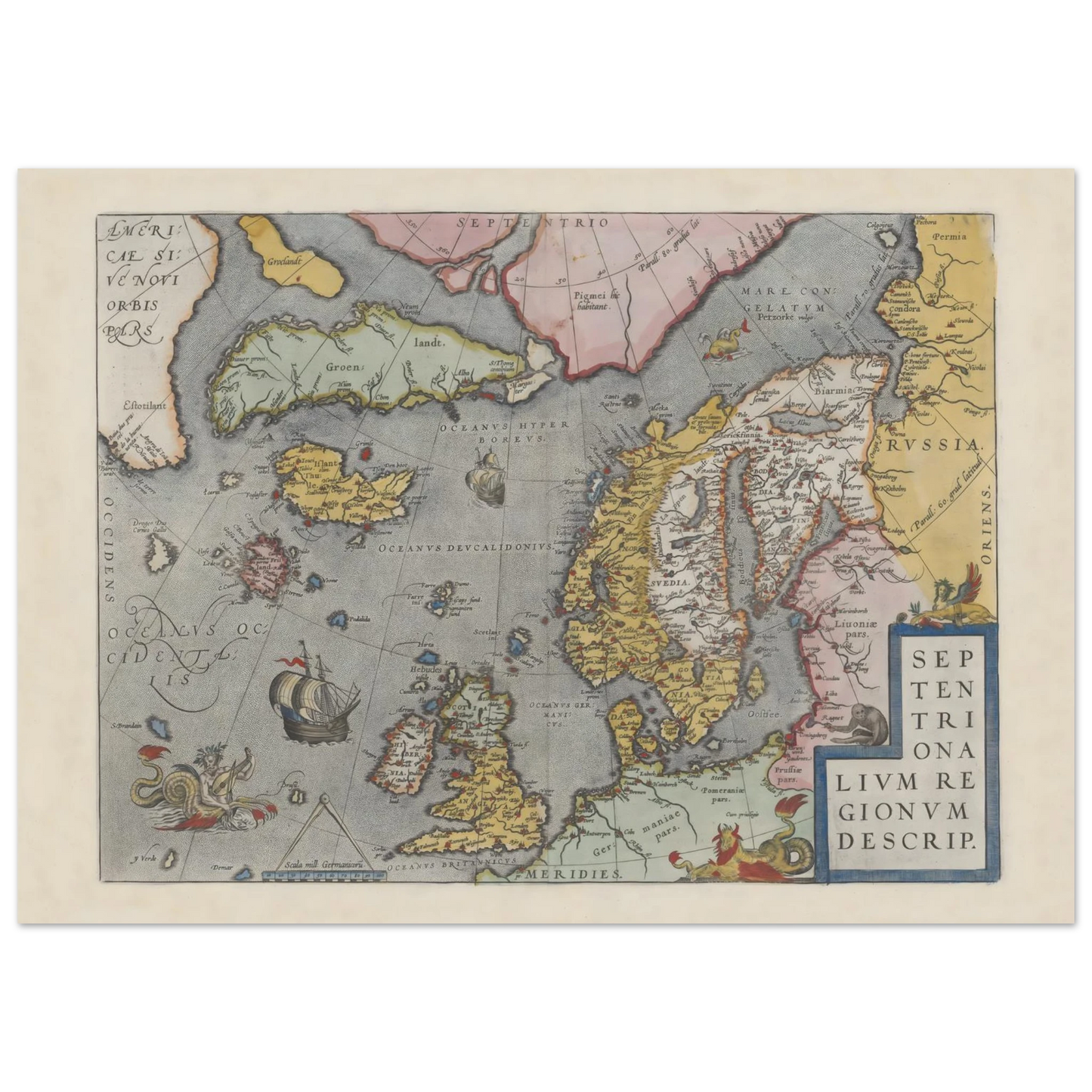
This Septentrionalium Regionum Descrip. poster brings 16th-century Nordic cartography, old-world detail and Scandinavian heritage into the home. Based on Abraham Ortelius’ famous map of the northern regions, this historic Scandinavia map print shows Scandinavia, Northern Europe, the North Atlantic, Iceland, Greenland and surrounding lands as they were imagined and mapped in the age of early modern atlases.
Couldn't load pickup availability
Secure and trusted checkout
Your payment information is processed securely. We do not store payment details nor have access to your payment information.
- Locally produced
- Easy Returns
- Quality Guarantee
Read more
Read more
This Septentrionalium Regionum Descrip. poster brings 16th-century Nordic cartography, old-world detail and Scandinavian heritage into the home. Based on Abraham Ortelius’ famous map of the northern regions, this historic Scandinavia map print shows Scandinavia, Northern Europe, the North Atlantic, Iceland, Greenland and surrounding lands as they were imagined and mapped in the age of early modern atlases.
It is ideal for studies, libraries, hallways, offices, heritage homes and gallery walls where wall art should feel historic, detailed and deeply connected to Nordic geography.
Quick Highlights
- Historic map print by Abraham Ortelius
- Based on Septentrionalium regionum descrip.
- Strong Scandinavian and Northern Europe map motif
- Shows Scandinavia, the Nordic region, North Atlantic, Iceland and Greenland
- Connected to Ortelius’ landmark atlas Theatrum Orbis Terrarum
- A meaningful choice for Scandinavian heritage homes
- Premium matte paper with a smooth, non-reflective finish
- Made when you order, close to the customer where possible
- Available in 6 sizes
- About This Ortelius Scandinavia Map Poster
Abraham Ortelius was one of the most important cartographers of the 16th century. His atlas Theatrum Orbis Terrarum is widely associated with the rise of the modern printed atlas tradition.
This Septentrionalium Regionum Descrip. poster is based on Ortelius’ map of the northern regions. The map presents Scandinavia and the wider North Atlantic world with remarkable visual richness: Norway, Sweden, Denmark, the Baltic region, Iceland, Greenland, parts of the British Isles and surrounding seas all become part of one dramatic northern image.
The map is especially interesting because it combines geography with imagination. It reflects real 16th-century knowledge of Scandinavia, but also includes the visual language of early modern cartography: sea creatures, ships, mythical islands, decorative lettering and a sense of discovery.
For the digital source, see the National Library of Norway’s digitized map. For broader catalogue context, see BnF’s catalogue record for Septentrionalium regionum descrip. and Wikimedia Commons’ National Library of Norway image reference.
Explore more Old Maps of Scandinavia, or pair this Ortelius map with Danish art prints, Norwegian posters and Swedish art prints for a gallery wall rooted in Nordic history and geography.
Cultural Source Note
BnF identifies Septentrionalium regionum descrip. as a cartographic image drawn from Ortelius’ Theatrum orbis terrarum. The catalogue connects the map with Scandinavia, the Arctic, Greenland, Iceland and the British Isles.
This makes the poster more than a decorative old map. It is a window into how Northern Europe and the Nordic world were represented in early modern European cartography.
Why It Works in a Scandinavian Home
| Room | Why it works |
|---|---|
| Study or library | Adds history, geography and old-world character |
| Home office | Brings structure, detail and intellectual atmosphere |
| Hallway | Creates a strong Nordic heritage first impression |
| Living room | Works as a refined conversation piece |
| Gallery wall | Pairs beautifully with Scandinavian maps, landscapes and classic art |
For a more layered wall, combine this print with Old Maps of Scandinavia, Scandinavian wall art and nature-based pieces from our Nordic Nature posters collection.
Size Guide
| Size in cm | Approx. size in inches | Best for |
|---|---|---|
| 13 × 18 cm | 5 × 7 in | Small frames, shelves and desk styling |
| 30 × 40 cm | 12 × 16 in | Hallways, shelves and compact gallery walls |
| 40 × 50 cm | 16 × 20 in | Offices, bedrooms and balanced wall displays |
| 50 × 70 cm | 20 × 28 in | Living rooms, studies and statement map displays |
| 60 × 80 cm | 24 × 32 in | Larger rooms and heritage walls |
| 70 × 100 cm | 28 × 40 in | Spacious interiors and large Scandinavian gallery walls |
Product Information
| Feature | Details |
|---|---|
| Product type | Historic map print poster |
| Map title | Septentrionalium regionum descrip. |
| Cartographer | Abraham Ortelius |
| Region | Scandinavia, Northern Europe and the North Atlantic |
| Product date context | 1575 |
| Atlas context | Theatrum Orbis Terrarum |
| Style | 16th-century engraved map, early modern cartography |
| Subject | Scandinavia, Nordic regions, Iceland, Greenland, North Atlantic and surrounding seas |
| Paper | Premium matte paper |
| Paper weight | 200 gsm / 80 lb |
| Finish | Smooth, non-reflective finish |
| Production | Made when you order, close to the customer where possible |
| Best for | Studies, offices, libraries, hallways, heritage homes and gallery walls |
The poster is produced on premium matte paper with a smooth, non-reflective finish — a good match for historic map details, fine linework, decorative lettering and vintage Scandinavian cartography.
What makes this Ortelius Scandinavia map poster special?
This Septentrionalium Regionum Descrip. poster is special because it is based on Abraham Ortelius’ historic map of the northern regions. It shows Scandinavia, Northern Europe, Iceland, Greenland and the North Atlantic through the visual language of 16th-century cartography, making it a meaningful old map print for Scandinavian heritage homes.
Explore Related Scandinavian Prints
Explore more Old Maps of Scandinavia in our map collection, or pair this Ortelius poster with Danish art prints, Norwegian posters and Swedish art prints for a gallery wall rooted in Nordic culture, history and geography.
You can also browse all art prints or discover more historic names on our Scandinavian artists page.
Cultural Context and Further Reading
For more background, visit the National Library of Norway’s digitized map source, BnF’s catalogue record for Septentrionalium regionum descrip. and Wikimedia Commons’ National Library of Norway image reference.
FAQ
What is this print?
This is a Septentrionalium Regionum Descrip. poster based on Abraham Ortelius’ historic map of the northern regions.
Who was Abraham Ortelius?
Abraham Ortelius was a 16th-century cartographer from Antwerp, best known for his atlas Theatrum Orbis Terrarum. His maps helped shape how Europe visualized the world in the early modern period.
What does the map show?
The map shows Scandinavia, Northern Europe, the North Atlantic, Iceland, Greenland, parts of the British Isles and surrounding northern regions.
Is this a Scandinavian map print?
Yes. This is a Scandinavian map print because Scandinavia and the Nordic regions are central to the composition.
Why does the map include mythical or unusual geography?
Early modern maps often combined direct geographical knowledge with older sources, travel accounts and cartographic imagination. That is part of what makes 16th-century maps so visually and historically fascinating.
What rooms does this poster suit?
It suits studies, offices, libraries, hallways, living rooms and Scandinavian gallery walls.
What sizes are available?
Available sizes: 13×18 cm, 30×40 cm, 40×50 cm, 50×70 cm, 60×80 cm and 70×100 cm.
View full details



Don't forget your discount
Buy 2 posters and get the 3rd at 50% off.
The discount applies to the lowest-priced poster and is automatically deducted at checkout.
Join our Scandi Club and get 10% off your order.
Sign up and enjoy your member discount.
Excellent Reviews


 Verified
Excellent quality
My print arrived quickly. The ink and paper quality was exceptional. I highly recommend these prints.
Verified
Very happy
I'm very happy with my beautifull print. Good quality of paper and bright colours. Delivering went smooth and fast. Very helpfull people.

Created on request - near you.
- We only print when you order, using FSC-certified or equivalent matte paper (200 gsm, 0.26 mm) for a refined, non-reflective finish.
- Local production across the USA, Europe, Australia, New Zealand, and Brazil helps reduce shipping distance and emissions.

Compare size
How is your poster going to look on your wall?
- Choosing a selection results in a full page refresh.
- Opens in a new window.