

Kjøp mer og få fri frakt
Sweden and Norway Map after Anders Bure, c. 1630
Sweden and Norway Map after Anders Bure, c. 1630
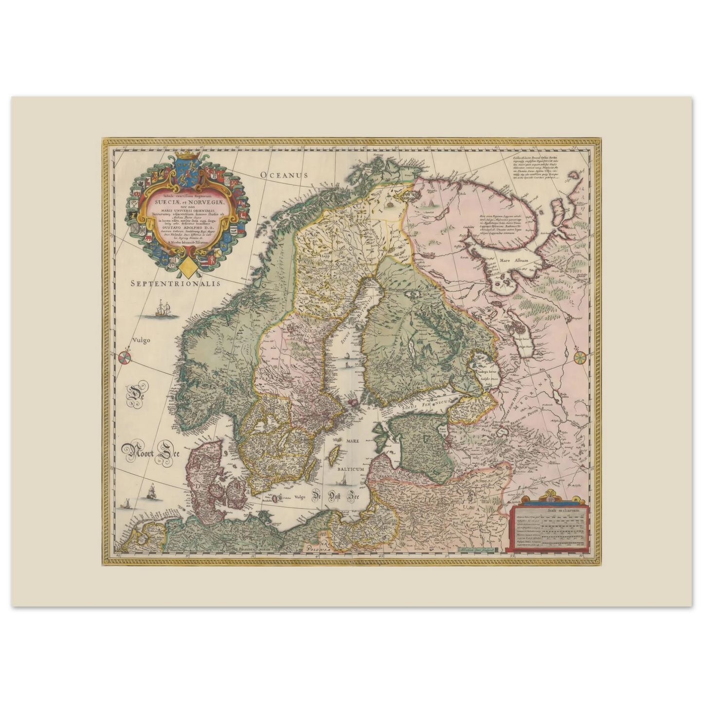
This historic map of Sweden and Norway presents Scandinavia and the Baltic region through the eyes of 17th-century European cartography. Based on Anders Bure’s influential mapping of the Nordic countries, the hand-coloured copper engraving combines remarkable geographical detail with heraldry, sailing ships and an elaborate royal cartouche.
Kunne ikke laste inn hentetilgjengelighet
Sikker og pålitelig utsjekk
Betalingsinformasjonen din behandles sikkert. Vi lagrer ingen betalingsdetaljer og har heller ikke tilgang til betalingsinformasjonen din.
- Lokalt produsert
- Enkel retur
- Kvalitetsgaranti
Les mer
Les mer
This historic map of Sweden and Norway presents Scandinavia and the Baltic region through the eyes of 17th-century European cartography. Based on Anders Bure’s influential mapping of the Nordic countries, the hand-coloured copper engraving combines remarkable geographical detail with heraldry, sailing ships and an elaborate royal cartouche.
Why this historic Scandinavian map stands out
- Detailed 17th-century map of Sweden, Norway and the Baltic region
- Based on the pioneering cartography of Anders Bure
- Engraved by Amsterdam mapmaker Abraham Goos
- Associated with publisher Claes Jansz. Visscher
- Shows Norway, Sweden, Finland, Denmark and surrounding territories
- Decorated with regional coats of arms, ships and compass roses
- Reproduced from a hand-coloured copper engraving
- Original preserved by the National Library of Norway
- Printed on premium 200 gsm matte paper
- Produced using FSC-certified paper
- Available in five sizes
- Made when ordered and produced close to the delivery destination where possible
- Typical delivery: 2–5 business days
- Frame is not included
A landmark map of Northern Europe
The map’s full Latin title begins Tabula exactissima Regnorum Sueciae et Norvegiae, meaning “A most exact map of the kingdoms of Sweden and Norway.” Its geographical reach extends beyond those kingdoms to Finland, Denmark, the Baltic Sea and neighbouring areas of Northern Europe.
The map derives from the work of Swedish cartographer, mathematician and surveyor Anders Bure. His vast six-sheet map of Scandinavia from 1626 gave the region a far more recognisable geographical form and became an important source for European map publishers throughout the 17th century.
This more compact interpretation was engraved by Abraham Goos and issued in Amsterdam within the publishing circle of Claes Jansz. Visscher. The cartouche is dedicated to King Gustavus Adolphus of Sweden and surrounded by a colourful arrangement of regional coats of arms.
Mountain ranges are shown as rows of shaded profiles. Towns, rivers, coastlines and political territories fill the land, while sailing ships and compass roses animate the surrounding seas. A separate scale cartouche records several regional measurements of distance.
The design is commonly associated with a date around 1630, which also appears in the National Library’s alternative title. The library dates this particular surviving impression more cautiously to sometime between 1640 and 1670.
“Bure has rightly been called ‘the father of Swedish cartography.’”
Source: Svenskt Biografiskt Lexikon, Swedish National Archives (translated from Swedish).
View the digitised original at the National Library of Norway.
Explore more historic Scandinavian maps, or browse our collection of Norwegian art and heritage posters.
Map facts
| Short title | Tabula Exactissima Regnorum Sueciae et Norvegiae |
|---|---|
| Full subject | Sweden, Norway, Scandinavia and the Baltic region |
| Cartographic source | Anders Bure (1571–1646) |
| Engraver | Abraham Goos (c. 1590–1643) |
| Publisher | Claes Jansz. Visscher (1586/87–1652) |
| Commonly associated date | c. 1630 |
| Dating of this impression | Catalogued cautiously as between 1640 and 1670 |
| Place of publication | Amsterdam, Netherlands |
| Original technique | Hand-coloured copper engraving |
| Original dimensions | 43 × 52 cm |
| Language | Latin |
| Relief representation | Mountain profiles |
| Collection | National Library of Norway |
| Permanent identifier | URN:NBN:no-nb_digikart_21g101641 |
| Print production | Made when ordered and produced close to the delivery destination where possible |
FAQ
What does Sueciae et Norvegiae mean?
The Latin phrase means “of Sweden and Norway.” The full title describes the map as a highly detailed representation of the two kingdoms and their neighbouring regions.
Who created the map?
The geographical information was based on the work of Anders Bure. Abraham Goos engraved the map, and it was issued within the Amsterdam publishing circle of Claes Jansz. Visscher.
When was the map published?
The design is commonly dated to around 1630. The National Library of Norway catalogues this particular impression more broadly and cautiously as having been published sometime between 1640 and 1670.
Which countries and regions appear on the map?
The map covers Norway, Sweden, Finland, Denmark, the Baltic Sea and surrounding parts of Northern and Eastern Europe.
What are the coats of arms around the title?
The decorative cartouche contains regional coats of arms connected with the territories of the Swedish realm and neighbouring Nordic regions.
Where is the source map preserved?
The digitised original used as the historical source belongs to the National Library of Norway.
Is the frame included?
No. The poster is supplied unframed, allowing you to choose a frame that suits your interior.
Where is the poster produced?
Each poster is made when ordered and produced close to the delivery destination where possible. Typical delivery is 2–5 business days.
Vis alle detaljer



Ikke glem rabatten din
Kjøp 2 plakater og få den 3. til 50 % rabatt.
Rabatten gjelder den rimeligste plakaten og trekkes automatisk fra i kassen.
Meld deg inn i Scandi Club og få 10 % rabatt på din bestilling.
Meld deg inn og nyt medlemsrabatten din.
Utmerkede anmeldelser


 Verified
Utmerket kvalitet
Trykket mitt kom raskt. Blekk- og papirkvaliteten var enestående. Jeg anbefaler disse trykkene på det sterkeste.
Verified
Veldig glad
Jeg er veldig fornøyd med mitt vakre trykk. God papirkvalitet og klare farger. Leveringen gikk knirkefritt og raskt. Veldig hjelpsomme folk.

Laget på forespørsel – nær deg.
- Vi trykker kun på bestilling, og bruker FSC-sertifisert eller tilsvarende matt papir (200 g/m², 0,26 mm) for en raffinert, ikke-reflekterende finish.
- Lokal produksjon i USA, Europa, Australia, New Zealand og Brasil bidrar til å redusere fraktavstand og utslipp.

Sammenlign størrelse
Hvordan kommer plakaten din til å se ut på veggen din?
- Ved å gjøre et valg vil hele siden lastes inn på nytt.
- Åpner i et nytt vindu.